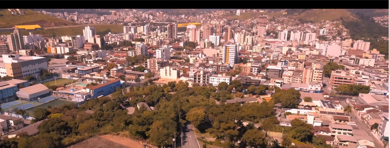
Orientation: how Ipatinga is laid out
Ipatinga sits in the Vale do Rio Doce in eastern Minas Gerais, near the confluence of the Piracicaba and Doce rivers, and forms part of the Vale do Aço metropolitan region. The city grew up around the Usiminas steel plant, with the original "Workers' Village" neighborhoods laid out between the Piracicaba River and the plant, and later neighborhoods spreading out for residents not tied to the company. For a visitor, this means the urban area is compact and contiguous rather than a scattered patchwork of distant districts, which makes getting around fairly straightforward.
Rail, metro and trams
Ipatinga has no metro or tram network for visitors to use. The city's rail history is tied to the Vitória–Minas Railway (EFVM), whose construction through the region drove settlement along the Doce and Piracicaba rivers, and the town's early stations—Pedra Mole, Nossa Senhora and later a terminal in what is now the Center—are part of that story. Today, however, there is no passenger rail service described for getting around the city, so plan on road-based transport.
Buses and public transport
City buses are the backbone of local public transport. The practical tool for visitors is IpaMove, a free app that provides real-time information on Ipatinga's buses. With it you can:
- See a map of nearby bus stops and ticket purchase points
- Check timetables for city lines
- Track vehicles in real time along their routes
- Plan a trip between two points, combining walking and public transport with live information
- Receive alerts about disruptions to routes or stops
- Save favorite lines, stops and planned trips
The app also supports accessibility features via TalkBack for arrival predictions, timetables and directions. It requires Android 5.0 (Lollipop) or later; on older devices, use a web browser instead. Because the app shows ticket purchase points on its map, you can buy fares locally rather than relying on a card you don't have.
For travel beyond the city, the intercity bus operator Presidente connects Ipatinga with Belo Horizonte and with nearby towns in the region, including Coronel Fabriciano, Timóteo, Caratinga, Inhapim, Iapu, Dom Cavati, Tarumirim and Ubaporanga. Tickets can be booked online as e-tickets that don't need printing. Note that Presidente's buses have no toilets and no Wi-Fi, so plan accordingly on longer rides.
Taxis and ride-hailing
As a practical matter, treat taxis and app-based rides as a backup for late nights or trips the buses don't cover well, and confirm options with your accommodation on arrival.
Walking
Ipatinga's urban core is compact—the municipality's urban area is a modest share of its territory—and the original planned neighborhoods were laid out close together between the river and the plant. Central sights such as Shopping Vale do Aço, Ipanema Park, Usipa and the Usiminas Cultural Center are the kind of destinations you can reasonably combine on foot within a district, though the city's hilly terrain and tropical heat make walking between distant neighborhoods less appealing. The IpaMove trip planner can mix walking with buses, which is the most practical way to cover longer hops.
Getting from the airport into the city
What is clear is that flying is a recognized alternative to the bus on the Ipatinga–Belo Horizonte corridor, so air connections to the state capital exist. If you fly in, arrange your onward transfer—taxi or pre-booked ride—through your accommodation, and use IpaMove to pick up a city bus once you reach the urban area.
Practical tips
- Install IpaMove before you arrive; it's the single most useful tool for navigating local buses, with live vehicle tracking and disruption alerts.
- Book Presidente intercity tickets online as e-tickets—no printing needed—and expect a long ride to Belo Horizonte with no onboard toilet or Wi-Fi.
- Don't count on rail or metro; all practical movement is by road.
- Cluster your sightseeing by neighborhood to keep walking manageable, and fall back on buses for longer cross-town trips.