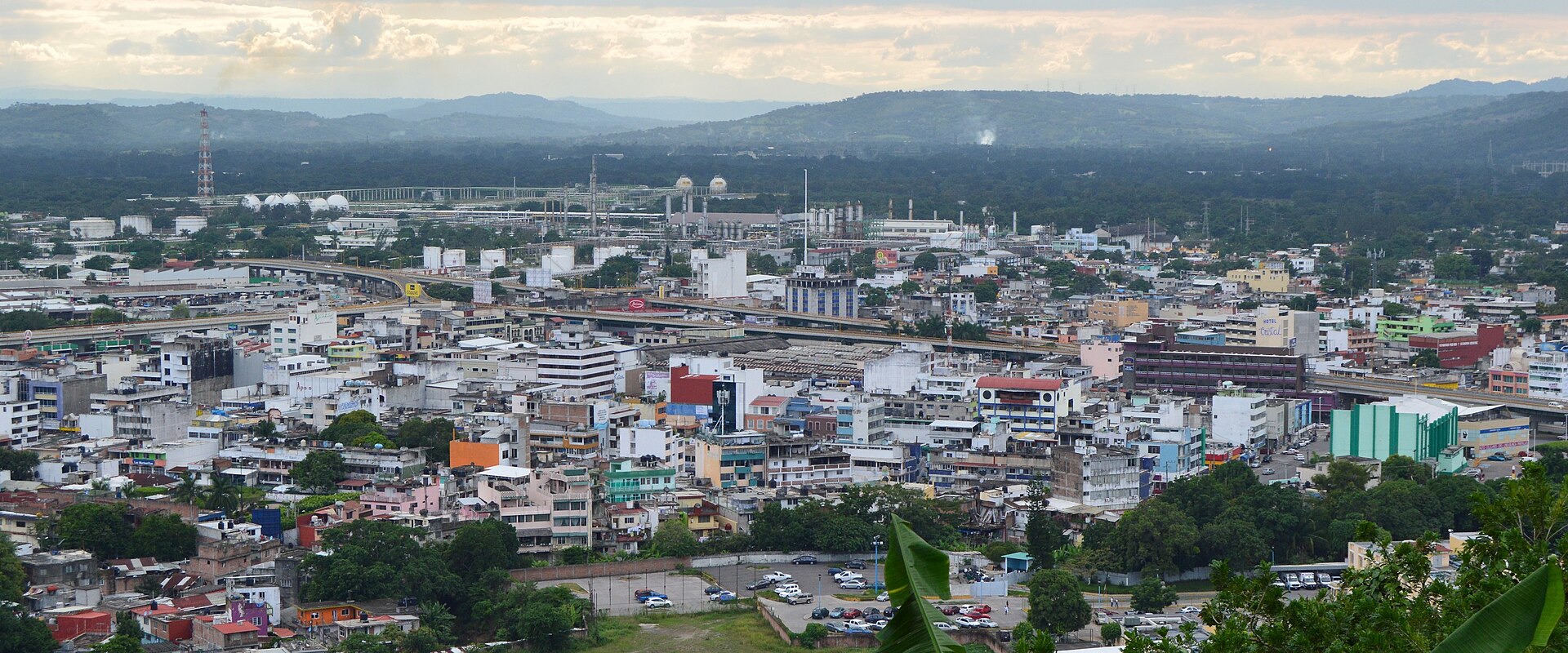
Poza Rica de Hidalgo
Introduction
Poza Rica de Hidalgo is a city and municipality in the Mexican state of Veracruz. Its name means "rich well" or "rich pond" — a reference not to oil, but to a pond that was once rich in fish and gave the settlement its name.
Oil was discovered in the area in the twentieth century, and the city grew around the industry that followed. That oil has since been almost completely extracted, and exploration and drilling have declined, though many oil facilities remain part of the landscape.
Before you go
Poza Rica takes its name from the abundance of fish once found here, though in modern times it is known as an oil town and an important industrial and commercial centre. It is also a central hub for several road transportation lines, which makes it a practical base for reaching other parts of the region. The city is a new one, founded in 1951, so expect contemporary architecture and well-lined, designed streets with a modern look rather than a historic centre.Getting there
Poza Rica sits roughly 220 km (140 mi) from Mexico City, and the bus is the practical way in. The city's main terminal, the Central de Autobuses on Av. Puebla in Palma Sola, in the northwest of the city near federal highway MEX-180, handles more than 30 lines arriving from across the country, among them Estrella Blanca, ADO, ADO GL, Platinum ADO, Futura, Omnibus de Mexico and others. The station has a spacious modern waiting area, restrooms and food services. Two auxiliary terminals complement it: one operated by ADO serves only passengers heading to neighbouring Tuxpan, while a third, in the Petromex area, handles departures south toward Xalapa, Veracruz, Coatzacoalcos, Villahermosa, Ciudad del Carmen and Chiapas.
By air, El Tajín National Airport (PAZ) in Tihuatlán serves Poza Rica, with a single runway and a small commercial passenger terminal. It has no scheduled commercial service, so it is used by business jets and private aircraft rather than by travellers on regular flights.
Getting around
Poza Rica has no metro, tram, or passenger rail, so you'll get around entirely by road: buses, taxis, shared taxis, and your own two feet. Public transport is bus-based, with routes serving different parts of the city rather than a numbered system, so you'll need to know which route reaches your destination. Shared taxis, known locally as peseros or colectivos, run fixed routes through the city and to neighbouring towns and are what locals use most. Regular taxis are plentiful and are the most common choice for travellers; Uber also operates here and lets you avoid carrying cash.
Central areas are reasonably straightforward to navigate on foot, since the city is modern and contemporary rather than colonial, with well-lined streets. Useful landmarks for orienting yourself include Poza Rica Center, the commercial heart, and Parque Plaza March 18, the central park between Avenues Lázaro Cárdenas and Calle 8 Norte. Be aware that much of the land is uneven, with hills mostly to the northeast, so some areas are steeper than the centre. For longer trips, note that the city's bus terminals serve different destinations: the Central de Autobuses in the northwest near Federal Highway MEX-180 handles most national lines, the ADO terminal only serves Tuxpan, and the Petromex terminal covers routes south such as Xalapa, Veracruz, and Coatzacoalcos. Check which terminal your route departs from, and carry small change or use Uber if you'd rather not handle cash.
Where to stay
For budget travellers, Hotel Florencia in Colonia Benito Juárez offers clean, comfortable rooms at affordable prices, with off-street parking and an on-site restaurant and bar.
- Hotel Cristal serves a nice breakfast spread and has a restaurant for lunch and dinner, with spacious rooms and beds.
- Hotel Poza Rica puts you in the center of the action, surrounded by stores and restaurants, and offers breakfast, a gym and a restaurant.
- Paris Hotel in Cazones is a moderate option with spacious, comfortable rooms, an on-site buffet restaurant and a gym.
Food & drink
Poza Rica's kitchens draw on the Totonac and Huastec traditions of the surrounding region. The dish most associated with the area is zacahuil, a large tamale you will see referenced wherever local food is discussed. Alongside it, expect a spread of familiar Mexican snacks: sopes, bocoles, molotes, tlacoyos, enchiladas, and blanditas.
- For an inexpensive, unfussy meal, Cafe Manolo on Calle 10 Ote in Obrera is a long-established diner serving traditional Mexican cooking. The food is good and cheap, though service can be slow and the setting plain.
- El Mesón Huasteco on Calle 2 de Enero in Cazones is the place to go for Huastecan and Totonacan cooking.
- El Pescador Veracruzano on Av. Puebla in Palma Sola specialises in seafood, with coconut shrimp and oysters among its standout dishes; it also serves soups, meat dishes, and tortas, and offers carryout.
- At the upscale end, La Tradicional Brasa y Fuego on Av Uno in Cazones serves prime cuts of beef. It runs two menus: a traditional one built around grilled meats and the Cielito Lindo menu, which ranges into international dishes including Asian cooking. There is a full bar, occasional live music, and off-street parking that fills up quickly.
What to see and do
For a view over the city and its surroundings, head to Parque de las Americas, where you can take in panoramic vistas and enjoy the outdoors. The most significant artistic work in the region is the Pablo O'Higgins mural on the façade of the municipal palace, titled "From the primitive pre-Hispanic agricultural work to the current development of the oil industry" — an innovative technique gave it the tonalities and nuances of a fresco, making it the first outdoor mural of its kind. If you're in the city during March, the Fiestas del Petroleo brings concerts, regional dances, a midway with rides and mechanical games, food and drink, a parade, and even a technical conference for people in the petroleum industry. Beyond the city, the archaeological zone of El Tajín lies about 15 km away, and to the northwest you can visit Castillo de Teayo, a small site centred on a large pyramid temple built between the 10th and 12th centuries by the Huastec civilization, a Mayan splinter group that remains among the least studied of the Mesoamerican cultures. A small INAH-operated museum there exhibits sculptures and relics from the site, including representations of gods, animals, and humans, several with a phallic fixation. The area is tropical, with several beaches within an hour of the city: Cazones is about 40 minutes east, while Tuxpan and Tecolutla are roughly an hour away and are considered the better beaches. You can also seek out the Los Huehues y Matarachín dances, traditional masked performances reflecting Totonac culture, staged during various cultural heritage events.Three days in Poza Rica de Hidalgo
Day one: Arrive in Poza Rica, a city in the Mexican state of Veracruz whose character is bound up with oil. Settle in and get your bearings in the centre, where the streets and the pace of life reflect that industry. If you come in by bus, the Central de Autobuses on Av Puebla is served by lines such as ADO, ADO GL, Platinum ADO, Futura, Omnibus and Estrella Blanca, with connections to Mexico City, Tuxpan, Xalapa, Coatzacoalcos, Villahermosa, Ciudad del Carmen and Chiapas. If you fly, El Tajín National Airport lies near Tihuatlán. Use the afternoon to walk the central streets and eat Mexican food in the city.
- Arrive and orient yourself in central Poza Rica
- Bus connections from the Central de Autobuses on Av Puebla
- Flights via El Tajín National Airport near Tihuatlán
Day two: Give the day to the area around Poza Rica. Palma Sola is within reach, and the oil town of Petromex is part of the local landscape. Getting around is straightforward: public transport, shared and regular services, and Uber all operate here, so you can move between the centre and the surrounding settlements without a car of your own.
- Palma Sola
- Petromex
- Public, shared and regular transport, plus Uber
Day three: Use your last day for a wider look at Veracruz and the Gulf coast. Tuxpan lies to the north and Xalapa, the state capital, inland; Coatzacoalcos and Villahermosa are further along the southern route, with Ciudad del Carmen and Chiapas beyond. If you are heading back to Mexico City or onward to Puebla, the Central de Autobuses on Av Puebla is where you pick up the ADO, ADO GL, Platinum ADO, Futura, Omnibus and Estrella Blanca services. Check MEX departures if you are flying out.
- Tuxpan and Xalapa
- Coatzacoalcos, Villahermosa, Ciudad del Carmen and Chiapas
- Return to Mexico City or onward to Puebla from the Central de Autobuses on Av Puebla